Urban Planning - 3DStreet
Open 3DStreet

Solutions for Urban Planning

Create compelling 3D visualizations of street redesigns to engage stakeholders and build consensus for transformative projects.


TRUSTED BY

LA Metro
Town of Manchester, CT
City of Silverton, OR
World Bank Group
Delaware Valley Regional Planning Commission

Rapid Visualization

Create compelling street designs in minutes instead of days. What previously required expensive CAD software and specialized training can now be accomplished in a single session.

Accessible Urban Design

Professional-grade street design capabilities without the steep learning curve of traditional engineering software. Enable planners, advocates, and community members to create meaningful design alternatives.

Stakeholder Engagement

Show, don't just tell. Transform abstract planning concepts into interactive 3D visuals that community members can understand and provide meaningful feedback on.

Elevate Your Proposals

Elevate your project proposals with professional-quality visualizations that captivate stakeholders and decision-makers.

From Concept to Engineering

Start with quick concepts that can later be refined and exported to professional design software. Create a seamless pipeline from ideation to detailed engineering.

"We found the ability to instantly transform cross-sections designed in Streetmix to interactive 3D visualizations with satellite map layers in 3DStreet to be transformative to understanding the true impacts and benefits of the proposed project in context with the existing environment."
- Eric Mulinge, Transportation Analyst

Powerful Tools for Planning Professionals

Geospatial Integration

Ground your designs in real-world context with support for Google 3D Tiles, OpenStreetMap data, and Mapbox satellite imagery. Perfect for creating location-specific visualizations for any city or neighborhood.

Learn more

AR Ready Exports

Export your designs as AR Ready 3D models for on-site visualization with popular platforms like Adobe Aero and inCitu. Allow stakeholders to experience your designs in context, right at the project location.

Learn more

Comprehensive 3D Library

Access a growing library of street elements including traffic safety features, street furniture, pedestrian amenities, transit infrastructure, and more. Easily customize your scenes with just a few clicks.

Learn more

How Planning Professionals Use 3DStreet

Transportation Agencies

Visualize complete streets transformations, communicate safety improvements, build consensus for controversial projects, and generate compelling visuals for grant applications.

Urban Planning Departments

Create interactive visualizations for community workshops, evaluate multiple design scenarios quickly, integrate with existing GIS data, and develop compelling materials for public hearings.

Engineering Consultants

Enhance client presentations with interactive 3D models, differentiate proposals, facilitate more productive client feedback sessions, and export designs to AR for on-site stakeholder reviews.

Case Studies

Climate-Resilient Infrastructure for Kiritimati Island

The World Bank collaborated with 3DStreet to visualize sustainable transportation infrastructure for Kiritimati Island, the world's largest coral atoll. This project helped imagine climate-resilient solutions that could accommodate both current and future residents in the context of rising sea levels.

Read Case Study
Visualization of infrastructure on Kiritimati Island

Trenton Bike Plan Visualization

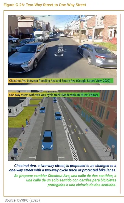
The Delaware Valley Regional Planning Commission utilized 3DStreet to create compelling visualizations for the "Trenton Bike Plan for All." These 3D models helped stakeholders understand proposed safety improvements and bicycle infrastructure designs.

View Project
Trenton bike plan visualization

Ready to Transform Your Planning Process?

Join the growing community of planning professionals using 3DStreet to build understanding and consensus for transformative street projects.